


- Atlantic "Mediterraneans"
- Bassin Caraïbe : caractéristiques physiques FR ES
- Caraibe : problématique d'une région FR ES
- Caraïbe, Nord et Sud entremêlés FR ES
- From one resource to another
Puzzle, patchwork, kaleidoscope are the words of diversity, indeed even of division, which come to mind when characterizing Caribbean space. The violence of contrasts and disparities, the myriad of islands and states, the multiplicity of cultures easily support this view.
The two worlds of continental mainland and island territories reveal different forms of spatial organization, development, mentalities, relations with the world and the sea. For the small islands, the sea uniquely is the horizon, the breath of life and umbilical cord, the element that essentially binds man and activity; in the large islands it plays a less exclusive role. By contrast, for the coastal mainland the sea appears somewhat repelling or inhospitable: it is in the interior where the population is concentrated, that the economy is largely centered.
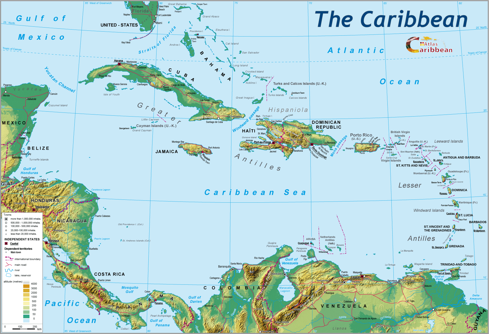
No less complex is the pattern of states. The archipelago by its very nature encourages micro-entities. For less evident reasons, the isthmus is equally finely divided into a series of small states.
By virtue of size, Mexico, Colombia and Venezuela remain apart. As for the United States, tutelary power, it seems at the same time both to be completely in the Caribbean and fundamentally outside its reality. Alongside the independent states, there are also non-sovereign territories in the archipelago, of varying status. Even if the most visible dictatorships that long flourished have fled the region, pluralist democracies still sit side by side with regimes that are more or less authoritarian.
This net whose mesh tightly draws together land and sea (Exclusive Economic Zones) also pulls together a multiplicity of currencies and units of measurement, laws and regulations, even driving on the left or right. It is equally synomous with visas, taxes, security checks, searches, hassle... Weakness (or) small size go hand in hand with national sensibilities and the nit-picking exercise of sovereignty. So many curbs on lawful means of all sorts, become a godsend to the illegal trafficking which prospers and excels at exploiting all the loopholes.
A combination of physical and political elements, and the diverse situations which result provide the geo-political backcloth to the region. The states, whether insular, isthmic or continental, have different perspectives on the region and world around them. It is fragmentation which dominates.
For centuries the archipelago was the first point of contact for navigators with the Caribbean. Isolated, the islands were not constrained in their external relations by the simple fact of physical proximity: not knowing the surrounding sea, they sailed without intervening breaks across wide expanses of water.
Their foreign policy, particularly that of small islands, is prudent and, above all, defensive, fed by a certain mistrust of the supposed grand designs of the continental mainland. The geopolitical importance of the islands cannot be understood in the same terms as for mainland states: counting for much more than their surface area, population and resources, is their geographical location, the intermediary links that can be made with the nearby mainland and, conversely, the latter's exercise of power towards them, as in the control of major sea routes. With the sea itself evoking freedom of passage, all the possibilities of ensuring open access for these internal seas to the ocean beyond takes on a particular strategic significance.
Jamaica's main geostrategic interest is the control of the sea route between the Panama Canal and the Windward Passage. Similarly, the Bahamas give the United States control of the Straits of Florida between the Gulf of Mexico, Florida and the Atlantic Ocean; as such they rate much more highly than larger or more populated islands. This is also the case with the strategic location of Grenada, astride the sea route from the Gulf of Mexico, linking the Caribbean basin to the South Atlantic, used to justify the brutal American military incursion there in 1983. The control of the Windward Passage, a major maritime thoroughfare, is amongst the reasons for the unremitting American struggle to topple the Castro regime. One other essential interest in islands today derives from their role in extending jurisdiction over maritime space: Venezuela and, to a lesser degree, Colombia are able, thanks to some tiny island relays, to deploy their presence and influence far away from their respective mainlands.
An island, physical entity with borders exactly defined by nature, often cultivates a sense of uniqueness, of being exceptional, the intensity of which appears sometimes inversely proportional to its size. To raised eyebrows, it openly seeks to have its sovereignty and specificity respected. Very often such insularity expresses itself as particularisms.
In such circumstances, the island accommodates itself as badly to membership of an association or federation, as to division. The logic of insularity – “one island, one state” – is further accentuated by the turbulent history of the Archipelago, and its physical, human and economic diversity.
Multi-island political constructions, ever fragile, are undermined by secessionism producing even further splintering and state proliferation: Trinidad and Tobago, Saint Kitts and Nevis. It is not then surprising that tentative moves towards federation have regularly collapsed. Again recently, efforts by the OECS to create a political union of the Windward Islands fell through. The Dutch islands, the richest of which subsidise the poorest, have questioned continued tutelage under the Curacao government. Aruba had already gained its independence in 1996. In contrast, Haiti and the Dominican Republic, coerced into sharing ‘against nature' the same island, continue to face structural tensions.
Certain islands seek to emphasize the advantage of their size, their demographic or economic weight. This is notably the case with Cuba: its renewed relations with the rest of the archipelago clearly presage its future influence. It is also that of Trinidad and Barbados, rivals for supremacy in the south of the Archipelago.
However, even if ‘a priori' the conditions for the establishment of intra-archipelago solidarity appear unlikely, it is the islands, above all the small ones, that come up with most of the internal initiatives for regional cooperation. They place much hope on the emergence of a Caribbean region as the only response to their weakness in the face of American hegemony. They see it also as an alternative, albeit partial, to over exclusive and destabilizing relations with an external power.
The central American isthmus acts, albeit in complex fashion, as both barrier and passage. Link between the two Americas, it constitutes the western barrier of the region and physically isolates it from the Pacific basin, whilst also providing the only point of passage between the two seas. The potential for conflict inherent in an isthmus is here powerfully reinforced by a political partitioning (into seven states) unique in the world, a break-up dating from the 19th century of the old Spanish Viceroys. This partition in effect provides a source of rivalry between countries which otherwise offer the same potential, particularly as regards an inter-oceanic junction. Old frontier disputes, control of the coasts, intra-regional rivalry, have further confused the situation.
‘Bi-maritimity'is the basic geopolitical element of isthmic states: they liken themselves to a hyphen, but the potential offered is very unequally exploited. The latter accords great significance to access to the two oceans, which wash their shores, guaranteeing them a double aspect. Those states which as a result consider themselves deprived (being hemmed-in is as much a matter of perception as an objective geographical reality), view their situation as they would an amputation, a major geopolitical handicap. To put an end to it becomes their key imperative. This, in turn, explains the number, seeming permanence and virulence of the ‘coastal wars,' which have torn the region apart for more than a century and a half. Obstinately, Guatemala has sought to enlarge its Atlantic opening at the expense of Honduras, and especially Belize, which is blocking the former's access to the Caribbean. The laborious process of normalization between the two countries dates from little more than a decade. On the Pacific side, it is against Salvador that this “hunger for its coast” has been directed.
Neither has Honduras ever accepted since its creation in 1844, the narrowness of its Pacific façade. Its policy of ‘opening out' provoked four wars with Salvador during the 19th century. More recently, the antagonism between the two countries came to a head in a mini-war on the football field. In 1992, a treaty put an end to their territorial disputes. For Nicaragua, boundary delimitation in the Gulf of Guanacaste remains the subject of serious liturgation.
For several isthmic states, the role of inter-face represents an additional geopolitical advantage. Guatemala again finds itself today with a pivotal role between the NAFTA group and central America, an advantageous position which allows it to exert a certain leadership across the isthmus, providing it can stabilize its own social and political situation. A country apart, Belize is a veritable “mainland island”' wholly turned towards the Caribbean. It owes it exceptional history to its strategic position, allowing it to control the Caribbean Sea. The only non-hispanic territory of the isthmus, it is also the only non-island member of CARICOM. British colonization was accompanied by development along its coastal sections of an economy, settlement and society more akin to the typical Antilles island model. Currently the country is attempting to reduce the gap between its geographical reality and present political reality, source of its ill-ease and marginality. The recent relocation of its capital from Belize City, on the Coast, to Belmopan inland is of strong symbolic significance. The normalization of relations with Guatemala for more than a decade is part of the same trend. This more effective isthmic integration may allow Belize to take better advantage of its strategic location.
Three mainland states, Mexico, Colombia and Venezuela appear as major regional players. To assume that geopolitical role, they lean on their territorial importance, population size and economic power, which places them well above others. They have concluded, more or less openly, that this gives them some natural claim to regional leadership. As coastal states, they look both to the sea (or seas in the case of Colombia and Mexico) and to the continental mainland. The Caribbean basin is but one of the directions to which they project their ambitious geopolitical dreams, in line with their geography … but not always supported by the means. Over time, all three have suffered deep frustration. After decolonization, they experienced a recessive territorial evolution “under a cloak of shame,” which would leave its traces. All their ‘legitimate' ambitions, constantly thwarted by the United States, the European powers or other mainland players like Brazil or Guatemala, would come to nothing. They regard the Caribbean as a zone of weakness, their own privileged domain of influence where their first attempts at exerting power meet far less resistance than in the case of their continental forays, but where also their ambitions risk clashes.
The regional role of the United States poses problems. Not that one can contest their role as the dominant regional power of long date, but that their hegemonic goal is distinct from, and even opposes, those aspirations towards region-building shared by all other countries of the region.
The five southern states of the US open out onto the Gulf of Mexico, but it is the Florida peninsula which is incontestably the most “Caribbean” of the Union. At its extremity, Miami projects American power out over the whole region, acting as the Caribbean gateway to the United States. Clandestine immigration, banking and narco dollars, tourism, and many more Florida links underpin the close relationship with the Caribbean.
The geopolitical orientation of each state is the product also of a subtle alchemy between multi-faceted elements, internal and external, ethnic, linguistic, religious, economic… 'In fine,' these geopolitical perceptions remain very largely a matter for the imagination, of representation across multiple collective and individual filters. The whole life of the region pivots around a dialectic of mosaic/coherence.
The different historical, cultural, economic, demographic combinations emerging from the temporal and spatial matrices of past centuries contribute, on the one hand, to portraying the ensemble of islands as the borders of a continent and, on the other, as partly coherent ensembles in themselves. In effect, this division appears with a stupefying constancy across the most diverse domains, with very few exceptions: thus it is the case for population densities (those of the Lesser Antilles are much higher than their Greater Antilles counterparts, themselves more densely populated than the mainland), for the HDI, life expectancy, dates of accession to independence (a delay of one and a half centuries between the isthmus and the Lesser Antilles), or again the establishment of democratic government, generally later in mainland Caribbean and the larger islands than in the small ones.
The make-up of the sub-regional economic organizations is particularly revealing of strong affinities and proximities, which are not merely geographical. On the contrary, links of all types between isthmus and archipelago for example, are well maintained; for an islander, that Cuba is Caribbean goes without saying, but what of Guatemala and Mexico?
The basis of the country identities across the region, whether ethnic, linguistic or religious have almost all been integrally cast in the colonial mould, and provide yet another powerful principle underlying the region's partition. The substitution by new populations of the exterminated original native inhabitants has been total in the Archipelago. In Central America, there remain Indian minorities of greatly varying size (totaling 1% in Costa Rica, 10% in Mexico, 50% in Guatemala), but part of which has abandoned its Indian roots to adopt the Hispanic culture and way of life, integrated within the ‘Ladinos' identity.
The inheritance from the British, Spanish, French, Dutch and Danish has left clearly defined cultural areas. Easily found, transcribed into tropical mode, are many of the distinctive traits of the old homeland: language obviously, religion, but also sporting pursuits, food habits, behaviour and attitudes. These different European worlds mix with each other almost as foreigners; each has its own economic organizations, its preferential air links, its universities. In the Lesser Antilles, in particular, historical and cultural proximities prevail over physical proximity. The example of Belize provides a case in point: Anglophone with its CARICOM membership ranking above its isthmic association.
At a finer level, a thousand ingredients, physical, human (with islands viewed as ‘black,' ‘white,' ‘mestizo,' to varying degree, with important variations in ‘indianess' across the isthmus), historical, cultural, economic, combine in their dosage to create subtle and complex cocktails from which the infinite nuances produce the ambiance, personality, identity of each fragment of Caribbean Space even and particularly, when it is very small.
Of Trinidad, the anthropologist David Crowley said that “an inhabitant of Trinidad sees no contradiction in being a British citizen, have a black skin, carry a Spanish name, be a catholic practicing African black-magic in private, lunch like a Hindu and dine like a Chinese.” The colonial mould in this instance has switched to impressionist mode. With infinite variation, this applies to a large part of the Caribbean.
The major economic fracture line which divides our planet, north from south, crosses this region. The boundary between the two zones, so clear on the mainland, is less so across the archipelago where they overlap more than they juxtapose, often producing over short distances markedly contrasting situations. Some small islands (Bahamas, Virgin Isles), in proximity to one of the world's poorest countries, Haiti, (the only representative of an LAC1 in the region) boast flattering indicators relating to income per capita, levels of schooling or household equipment which place them well above the countries of Central America, and the large islands of the north (Puerto Rico excluded). These gaps are again found in the range of stages of the demographic transition present within the region.
The paths of development adopted in recent decades translate into the same eclecticism: the traditional agriculturally-based, state-run, collectivized economy of Cuba is neighbor to numerous fiscal havens, multiple port free zones, Panama's flag of convenience, all openly inscribed within the logic of a highly liberalized global system.
The similarity of products and hence absence of complementarity, the feeble scale of internal markets and the vital necessity to export reinforces the imperative of competition rather than that of cooperation. This results in the full-blown competition between the “dollar bananas” of Central America and the “ACP bananas” of the island signatories of the Lomé Accords, and the “European banana” of the French West Indies. Neighbouring countries with similar problems and conditions find themselves embroiled in matters where the stakes and strategies are well beyond them, a source of both irritation and incomprehension, and in turn undermining their solidarity. Similarly, the recent massive growth of Cuba's tourism sector, and its likely future expansion in some southern and central American countries, is seen as threatening the attraction of traditional tourist destinations.
However, the simple enumeration of multiple characteristics or recognized indicators across the region can prove somewhat misleading. On the one hand, in all domains, some strongly dominant characteristic generally sets the tone for the whole. Which language counts, in terms of numbers of speakers, whether Dutch, French or even English, in the face of Spanish spoken from Florida to Venezuela, via Cuba and Puerto Rico? Again, non-democratic regimes are now the exception. The levels of living are generally below those of the developed world. On the other hand, it is largely the Archipelago, above all the small islands of the south, which give to the region this semblance of great diversity. The major division between Hispanic and Anglo-Saxon America, there becomes blurred by the French and Dutch “inclusions.”
Variety, diversity and mixture provide incontestable richness. They allow the Caribbean to exploit a unique resource, the sun, in innumerable ways and pull in the considerable tourist flows emanating from very different geographical horizons, but in a world of major powers, division, dislocation, fragmentation appear as a considerable handicap.
Powerful centrifugal forces of disaggregation are still in evidence across a still fragmented region that has never achieved an integrated existence. Independent or not, its states and territories have retained cultural and commercial links of a greater intensity with the outside world (their former European rulers or the United States) than with their neighbours. This outward orientation, sitting alongside a ‘turning inwards,' remains a heavy legacy.
Today, the Caribbean appears engaged in a dual logic of regionalisation and extending beyond compartmentalisation. The former is driven with resolve by the United States and draws upon an ALENA enlarged to include the whole of the American continent within the American Free Exchange Zone. It can only serve to reinforce a process, already well advanced, of regional ‘vassalisation' dictated through money markets, investments, etc. Several states in the region, concerned at possible marginalization have already committed to membership at different future dates.
The second, much more recent and innovative, is essentially defensive. It was given effect by the creation on 25th July 1994 of the ACS (Association of Caribbean States). It responds to a need for rapprochement, collaboration, coordinated policies, active solidarity with weak states that have a share in the Caribbean Sea, in its tropicality, history and heritage of slavery, colonisation and the close presence of the United States.
A time will come to judge the achievements of this young organization, whose very existence already represents an important step. The 25 independent states and 12 dependent coastal territories of the Caribbean Sea, breaching the redoubtable barriers that both man and nature have contrived to impose on the region, affirming their common interests, are signed up to a course of ambitious collaboration. The “Greater Caribbean” or the “Caribbean of the wider definition,” perceived and dreamed by some, has for the first time found institutional recognition. This attempt to break out beyond a compartmentalised world is very much a matter of politics, but its resilience largely surpasses this. In all the human actions that characterise the everyday in the Caribbean it is possible to read the ambivalence between maintaining difference and building together. The mosaic remains and will for a long time to come. As for the dividing lines, they may become less distinct.
1 Less Advanced Country.
top
|
  |
© 2007-2025 University of Caen Normandy,
CERTIC, UMR CNRS 6590 ESO, AREC, Research and Studies Association on Caribbean area, All Rights Reserved.  |

