


- Atlantic "Mediterraneans"
- Bassin Caraïbe : caractéristiques physiques FR ES
- Caraibe : problématique d'une région FR ES
- Caraïbe, Nord et Sud entremêlés FR ES
- From one resource to another
Human history’s long evolution has witnessed the progressive self-appropriation of land through the attribution, definition, and organisation of territories, each in relation to the other, and all achieved more often than not through violence. The Caribbean does not escape this general rule.
Ancient imprints left by the Amerindian peoples have almost wholly disappeared, save perhaps for the distribution of some plant species not known to later settlers. Here and there, scant remains of early societies are much more in evidence in the isthmus than across the archipelago.
The new arrivals from Europe, by wiping out the autochthonous peoples, also succeeded in eradicating their ancient names. Today, the Caribbean carries the imprint of European domination, “the European having demonstrated everywhere across the world by the use of the same means of nominally marking their acquisitions (indeed, leaving the same creative trademark), but nowhere as completely as in America” (Christian Grataloup, ‘Géohistoire de la mondialisation,’ Armand Colin, 2007).
As such, Caribbean Sea or Sea of the Caribbeans, contrary to what is generally believed, is not a name of Amerindian origin. It was the new settlers who would baptise it so. Did the inhabitants of these islands then have a clear idea of the immensity and unity of this liquid space? It is difficult to be certain, even in the knowledge that inter-island relations within the Lesser Antilles were well-developed, as well as relatively regular within the Greater Antilles given the level of technology available to these societies.
The Amerindian peoples of this region were known as the Kalinas, or Kalinagos in the South, and Tainos in the North.
Recently archaeologists and anthropologists have greatly increased our knowledge of these lost civilisations, allowing a better understanding of the Amerindian worlds: Caribs and Arawaks represent different belief systems, and a division between peoples on the one hand wrongly viewed as warrior-cannibals in the case of the Caribs, and on the other the more peace-loving Arawaks. Today, the confusion is seen to have originated from the use of a different form of language used by men and women. Even so, all are Amerindians arriving in successive waves from the Orinoco basin. As already noted above, these peoples, these peoples referred to themselves as Kalinas.
The Caribbean: forged by the Europeans
Persuaded that they had discovered a new world, the Europeans created a regional identity in the image of what they already knew. Their points of reference were named after places they had left behind (Cartagena), or those with a religious connotation (Santa Cruz, Vera Cruz, Santiago…). A few ancient toponyms survived, but remain rare. There are more often found on the continental mainland where the Amerindian populations were more concentrated, and where despite a catastrophic demographic decline, due largely to widespread pandemics, a cultural and ethnic remnant bas survived, not least because the colonisers were always relatively few in number. In 1969, Pierre Chaunu has estimated that around the year 1570 there were not more than 75 000 Spanish across the whole of America, of which probably some 15 000 were in Mexico. In the islands, the eradication of the existing population was both more rapid and more complete, albeit with some variation as in a few small islands, uninhabited at the time, conserving their denomination (the case of Cariacou or Mayéro in the Grenadines). Place names accordingly map the course of the conquest. Each conqueror would leave his own mark.
“Mediterranean” – a conceptual framework?
During the conference of July 2010 held in Santiago in the Dominican Republic, some controversy arose over the use by the authors of the Electronic Atlas of the notion of ‘Caribbean Mediterranean’ or ‘American Mediterranean,’ which in turn provoked lively debate.
Used in this sense, the world Mediterranean no longer only refers to the particular geographical place of that name, but to the functional mode of a defined maritime space and the land border that encloses it.
Geographers, as well as historians, have long sought to generate broader concepts derived from particular type examples. Hence a ‘Karst’ landscape is a topography crated out of thick beds of limestone that have been eroded by the dissolving action of water. The name originates from a region of former Yugoslavia. One could also cite the general adoption of the term loess (a loan soil covering vast plateau areas of China), or the ‘sabkha’ and ‘chott’ of North Africa (lacustrine depressions fillet with saline water), or again ‘taiga,’ and other such terms that have passed into common usage, such as ‘slave’ originating from the Slav peoples of Eastern Europe, captured and enslaved for over 2000 years.
Accordingly, the use of the term ‘Mediterranean’ should not be seen as implying pejoratively either any sense of dominance or any suggestion of “eurocentrism.” Otherwise, in order to avoid any conceptual body of language overly marked by pas subjection to Europe, perhaps one should seek to “de-christen” most of the named towns and sites of the Caribbean. Such cities as Port of Spain, Kingston, mountains such as Pico Duarte should change their name. However, as a consolation, several would remain – Oaxaca, and the Popocatepetl – but which for some would appear far removed from the Caribbean.
Nonetheless, the authors of the Atlas remain well aware of the ideological overtones of such terminology. Some will eventually disappear. Each word, each place helps to identify a society, but nothing is immutable. In the present context, the language used is that of the schools of geography, and of the social sciences to which they belong.
To what ware we referring when using the expression “American Mediterranean?”
It is only by reference to the eponymous sea that this expression makes any sense. The origin of the name is Latin, ‘medius,’ i.e. in the middle of ‘terra,’ the land. For a long time, the peoples bordering the Mediterranean simply called it ‘the Sea.’ It was only during the great age of discovery when the early navigators had mapped the relative importance of these marine expanses, namely the separate oceans, that “the Sea” became the ‘Mediterranean.’ In the 19th century, Alexander Humbolt and Elisée Reclus, whilst studying and discovering the Caribbean Sea, would use the term ‘American Mediterranean.’.
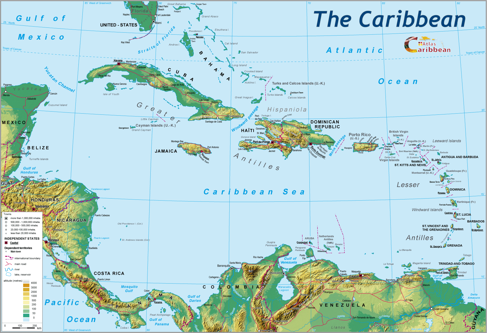
Clearly, there are physical differences between these two maritime regions. The surface area of the Caribbean is one and a half times greater than that of the internal European sea, 4.3 million sq. km as opposed to 2.99, and it is also deeper. Furthermore, the Mediterranean is largely closed, only linked to the Atlantic Ocean by the narrow Gibraltar Strait, some 20 km wide. Set within the Caribbean context this distance corresponds to less than half that separating Martinique from the island of Dominica.
The Caribbean Sea opens onto the Atlantic by way of a series of passages known locally as “canals.” Some are fairly narrow, as in the case of the passage separating the Saintes archipelago to the South of Guadeloupe from Dominica. Others attain widths of 80, even 100 km (Saint Lucia/Saint Vincent or Trinidad/Grenada). Within these “canals” sea currents and channelling of the waters are very evident. On the western flank of the Caribbean, the isthmus is narrow, with only the northern and southern land borders belonging to adjoining continents, whilst the Mediterranean is surrounded on all sides by imposing landmasses.
Even so, some physical similarities exist: both the Mediterranean and the Caribbean are at the junction of active tectonic plates, which occasionally provoke devastating seismic movements. Yet throughout history, they have both been crucibles in which brilliant civilisations have been forged.
Although the islands may appear distant from the mainland continent, links have never been totally severed. Very ancient Amerindian civilisations have pushed peoples from the West (Yucatán) towards the East, from the North (Florida today) to the South (Greater Antilles), and from the Orinoco basin to the North, conquering one by one the small islands of the Lesser Antilles. Spanish domination of the whole of the Caribbean Basin witnessed the continuation of old trading links, but also the development of new ones: ships, peoples, and produce circulated. The development of practical know-how, benefitting one and all, even during violent times, was multiple: examples abound from the tore-and-aft sail adapted by the autochthonous populations to the hammocks mounted later in transatlantic ships.
Presumably, if the Mayan city-states did not see any need to expand onto the islands, it was because food sources were adequate in respect of existing population densities. In contrast, the Mediterranean saw extensive migration and re-settlement of the Greeks into the western half of the basin.
Would it be going too far to suggest a parallel between the Roman Empire and that of Charles V, albeit 15 centuries apart? One would dominate the Mediterranean, the other the Caribbean, but both would witness the infiltration of diverse groups, foreigners, occasionally threatening for the weaker zones, the North and East in the case of the Roman Empire, and the islands with regard to the Caribbean. It would be interesting if such an idea could be developed by historians, however comparative history is not well represented in contemporary historiography.
What remains important, however, is the similarity in modes of functioning between the two maritime entities. In each basin, the differences between one side and the other, one locality and another, have contributed to a unified whole: commercial links, exchanges of produce, technologies, have enriched populations by modifying their ways of living. Maize originating from Central America would reach the Greater Antilles, and in turn the Lesser Antilles, whilst manioc from the Orinoco delta would slowly make its way to the islands from south to north not withstanding quasi-annual incidents with the Kalinagos. Everywhere, beans would provide the basic diet of the local population.
A parallel, and no more than that, can be made with the Mediterranean whose evolution was founded on wheat, the vine, and the olive, three staples shipped across the waves, traces of which today are still found by divers searching the seafloor.
Many other aspects offer comparisons. Piracy was a constituent element of these maritime spaces. If ‘Red Beard’ still haunts the canon of children’s literacy in the Caribbean, Barbarossa would achieve the same on the Algerian coast; the ‘buccaneers’ of Tortuga in turn would enriched the whole mythology of the ‘barbaresques’ (Barbary pirates).on the other side of the Atlantic. Literature, comic strips, cinema, all combined to promote such stories, so widespread as to become universal. Other elements would prove less glorious in this human story connecting the two seas: the human trafficking, slavery bringing about the massive displacement of peoples, since earliest antiquity in the Mediterranean, and the 15th century in the Caribbean. If today there is a will to emerge from this ‘forgotten’ past in order to measure the legacy of this transatlantic black traffic, it is because European and African histories have sought to minimise the consequences of this slave labour in the Caribbean, and that the ‘racialisation’ of slavery provoked wounds that are still open. It is during the 17th and 18th centuries that the ‘black’ question became of subject of opprobrium. It was clearly necessary to justify such inequality, that of enslavement at a time when a new philosophy of the rights of men and of equality of citizens before the law as being sought.
Today, even though there clearly remain areas of commonality, the paths followed by these two maritime entities appear to be diverging. The Caribbean is a region where conflict remains of minor significance. Despite obstacles, the bordering states are in regular communication, exchange, and dialogue. The Mediterranean basin, however, remains victim to wars, violence, with two conceptions of the world and religions which confront each other.
Could one therefore imagine that the efforts made across the Caribbean might become a mode, and even entertain the thought that a new concept might emerge, that of “a European Caribbean?”
Back at the July 2010 conference, other key words came other discussion and where precise definition is required.
The word “mosaic” raised a number of comments
One needs to return to the original meaning of this word. A mosaic is an assemblage of small pieces of marble or coloured glass set in cement so as to produce an overall pattern. Homonymously, a mosaic is also a design, a schema intended to impact meaning. The Caribbean represents such an assemblage, strange at first sight with its multiple and different entities in respect of size (from the largest to the smallest), their different destinies shaped by multiple colonisers each stamping their own imprint, their dates of independence acquired at the beginning of the 19th century or, on the contrary, in the second half of the 20th. Then again there are those territories where the populations, yes the inhabitants themselves, decided to retain political links with their former metropoles. Relations between these territories and their metropoles are not necessarily caricatural. The choices of those peoples, even when set in the context of recent historical events, are those in favour of maintaining old established links. The latter must be taken into account as these islands remain exposed to ‘wind and tide’ in the Caribbean.
Saint Martin is often cited as the archetype of caribbeaness. This small territory certainly offers many of the traits of the Caribbean world: culture is one such element, but by no means the only one. And that is to omit mention of the choice of its inhabitants, who have adapted well to the dominant presence or continuing links that still remain strong with not just one metropole but two. The French half of Saint Martin opted some years ago for greater autonomy, whilst remaining within the bosom of France, by becoming an “overseas community.” As such, the territory gains administrative autonomy without losing the financial and social advantages of being attached to the French system.
For four centuries, the citizens of Saint Martin have enjoyed a comfortable lifestyle, and known how to exploit the weaknesses linked to the presence of a border with regard to different systems of health and education. In short, everyone benefits from such a situation. Furthermore, Saint Martin is very much ‘Caribbean’ in its propensity to attract a number of activities, only more or less lawful: the “casino” economy developed in the Dutch part of the island hardly provides the exemplar of what should be seen as Caribbean. However, it is obviously to seduce the cruise trade from the United States that so many casinos have been squeezed onto such a small area. It is ‘Las Vegas’ without Las Vegas!
Saint Martin is one of those small pieces of glass that make up and announce themselves as Caribbean in all its complexities and contradictions. How, amongst so many other territories, larger, richer, more populated, more innovatory, is its right to exist justified? How regionally within the wider league of “big players,” does it get out of any venture without loss?
Clearly, there are many other ‘pieces of marble’ just as eccentric in the mosaic. Dominica provides an example of self-sufficiency in food for its population, rightly viewed as an endogenous way forward in development terms. However, the latter has not prevented the country from signing conventions or obtaining accords with countries like China or Japan, which its supports in opposing quotas in the hunting of whales that after all remain part of a vital heritage in environmental terms. The financial aid and investment provided by these Asiatic powers is too important to put at risk. Here one sees how policy choices can appear ambivalent, even contradictory.
One could cite other examples and uncover the same dilemmas. The Caribbean Atlas is intended both to view the overall pattern as well as to provide a focus on the design of each of the constituent pieces of the mosaic.
“Backyard” of the United States, the giant’s “guardian shadow”: two expressions still the subject of debate
It might appear that a quick reading of the texts in the online atlas or the book Emerging Caribbean suggests a North American bias, indeed a stance even suggesting approval of US actions across the zone. The authors of the Atlas clearly have their opinions, but the position of researcher proscribes partiality and demands that a disinterested position be adopted in any observation, analysis, interpretation, or explanation. The latter is deduced from the study of texts, statistics, positions agreed with co-researchers, government declarations, votes in major international assemblies... Such an approach must also frequently draw on history in order to gain a grasp of continuities and ruptures within social groups, population, and their representatives.
In order to understand the usage of such terms, one must first agree on precise definitions. A ‘backyard’ is to be found adjoining a dwelling, an area providing clearance space, a place to provide storage, the prolongation of the house itself. The town houses of the francophone Caribbean often conform to this type of configuration: the ‘backyard’ is not accessible to ‘strangers,’ to the people of the street. It is the space that belongs to the inhabitants of the main residence.
“Guardian shadow” recalls the watchful role of a protective ruler: adult over child or over weaker persons. Such a dominant role can be troublesome, and at the very least charged with meaning. In the domain of geopolitics, it assumes even greater meaning. Since the middle of the 19th century, the United States has viewed this region as one within their controlling orbit. The aborted dream of creating a southern empire centred on the Caribbean Sea and the Gulf of Mexico, including those states south of the Mason-Dixon Line and the large islands of th archipelago, has not altered the US position regarding this region. The (too) many interventions from the end of the 19th century to the last quarter of the 20th, demonstrates their belief that the region is one of their reserved domains (by way of comparison, this echoes the vision of the Mediterranean in the mid-20th century, as representing in their eyes a bulwark against the USSR). The North American military bases, despite the deployments of recent decades, confirms albeit with less violence, the heavy presence of the United States. Their attitude up to the present towards Cuba, their deafening silence regarding the ‘coup d’état’ overthrowing President Zelaya in 2009 in Honduras, shows that the situation today is little changed. The tactics adopted are arguably less war-like and less brutal, but the attention given to the Caribbean is always sharp-edged. To be sure, they can certainly continue to profit from political upheavals, the political histories of each territory, the relations developed between each and every one of the neighbouring states, as well as occasionally from the territorial demands that although not provoking armed conflict, serve to maintain regional tensions.
Finally, it remains that the ACS does not have the capacity to oppose its powerful neighbour, but is the surest route by which to attract international attention. ALBA (Bolivarian Alliance for the Peoples of Our America) remains “the tree that conceals the forest” in the relations between the various territories of the Caribbean and the United States.
This ‘shadow,’ this geopolitical vision e still that of the North American state, but the actions involved are multiple, and all must assume their share of responsibility, to a larger or smaller degree depending on their size and wealth.
With little risk of being contradicted, it can be argued that overall democracy lives and is growing across the Caribbean. Here and there, imperfections, fragilities, deficiencies remain, but compared to many other states in the world, Caribbean live under legal regimes, even if in a few cases, the law is not always rigorously upheld. The latter helps to explain the positions taken by the elites, namely the governing bodies are the expression of the people.
As most of the states of the zone are members of the CBI, Richard Nixon’s great initiative, can one conclude that the Caribbean is not within the US orbit? When Barbados recognised that trade with her North American partner dropped by 80% at the beginning of the 2000 decade, in line with clauses contained within the CBI, what conclusion should be reach?
When Mexico in 2009 revealed the impact of the ravages of the free-market regime, put in place by NAFTA, on its maize production, particularly affecting small, peasant farmers, whose production as no longer competitive, how should one view these accords?
When in 2001, across all corners of the Caribbean one saw an outburst of slogans “we are all Americans, we are all New Yorkers,” even though in 1959 some 3 000 dead caused by an American bombing raid to capture General Noriega in Panama City barely raised any protest; did the silence at that moment indicate tacit agreement or simply a certain degree of prudence not to put at risk various economic, indeed political interests?
Today, numerous divergent positions remain between various sub-regional groupings. Overall the region is at peace and the United States looks increasingly towards Brazil, the emerging power. North American interests lie more to the South. What then is the future for the Basin? Many would wish that cooperation within the ACS would provide the basis of a different way forward, that will preserve economic development and the cultural wealth of the Caribbean. However, over the last 2 or 3 years, the ACS has said little.
Bibliography
Very extensive, so that only a few are listed.
Arrault Jean-Baptiste, A propos du concept de méditerranée, Expérience géographique du monde et mondialisation (article).
Braudel Fernand, La Méditerranée et le monde méditerranéen au temps de Philippe II, 2e édition, 1966.
Braudel Fernand, Les mémoires de la Méditerranée, Éditions de Fallois, 1998.
Grataloup Christian, Géohistoire de la mondialisation, Armand Colin, 2007.
Revue Hérodote La Méditerranée américaine, n° 27, 1982.
Revue Hérodote, Amériques, Nations Hispaniques, n° 99, 2000.
See also for English bibliographic sources
Bégot M., Buléon P., Roth P., Emerging Caribbean – A Political Geography, AREC, 2009.
Braudel F., The Mediterranean and the Mediterranean World in the Age of Philip II, Harper Collins (translated by Sian Reynolds), 1992.
top
|
  |
© 2007-2025 University of Caen Normandy,
CERTIC, UMR CNRS 6590 ESO, AREC, Research and Studies Association on Caribbean area, All Rights Reserved.  |

