


- Caribbean mobilities
- Colonization: an indelibly engraved imprint
- Dialogue on caribbean migration
- Freedom and new mobilities (19th C)
- Les décisions récentes de la politique migratoire en République Dominicaine FR
- Les migrations intra-caribéennes (2020) FR
- L’immigration haïtienne en République Dominicaine FR
- L’ "anti-haïtianisme" en République Dominicaine ? FR
- Migraciones de Haicianos ES FR
- Migrations (1960-1990)
- Migrations (1990-2010)
- Migrations 2010-2017 FR
- Migrations : nouvelles tensions FR ES
- Migrations intra-caribéennes FR
- Mobilities of violent appropriation
- Mobilités pendulaires et macrocéphalies urbaine et professionnelle : le cas de la Guadeloupe et de la Martinique FR ES
- Revolutions in energy and transport
The article that follow can be read separtely, focusing on each of the topics in question. They also from part of a literacy excursion on mobilities throughout the Caribbean since the 16th century:
♦ Colonization: an indelible matricised imprint
♦ Mobilities of violent appropriation: slave trade, privateering and piracy
♦ Emancipations and new mobilities in the 19th century
♦ Revolutions in energy sources and means of transport
This article attempts to address the evolution of the very notion of mobilities in the Caribbean from the pre-colonial period right up to the present day. It focuses above all on the only means of mobility available at any time, more than on the actors involved, who themselves are the flesh of Caribbean history. From such a perspective, the study seeks to demonstrate that the Caribbean basin was fully engaged in the whole historical adventure of means of transport. The human cost often proved cruel, as during the long period of the slave trade. If Caribbean humankind today is so diverse, it is because of the incessant flows that brought both the enslaved and the free, having generated a continuous flux of goods and riches. Lands of immigration became lands of emigration, such that the Caribbean could be seen as a crossroads. Starting with the first Amerindian wanderer winding his way across the middle-American Cordillera, or the Caribbean dug-out canoeist padding from island to island, one ends up with the present-day tangled network of air, sea and IT communications that have transformed the Caribbean into a vital junction zone, which regretfully manages to control less than being itself controlled. This complex canvas, does it not serve to confine the region more each day in an extroversion that internal connection fail to counter balance? Unless of course it is tying it more solidly, and with even greater solidarity, to the contemporary world.
The study of such mobilities across the centuries had had to be undertaken with much more limited data than that implied in the ‘tourist-ludic’ images projected in the leaflets of travel agencies. This analysis accordingly starts with a reminder of the difficult natural environment that confronts all forms of movement before any pretension to control, or at least leaving some major and indelible imprint.
Against this natural setting, Caribbean mobilities may be placed within a fourfold time frame, albeit of periods of unequal duration. The first starts with the pre-colonial period which leaves the slightest imprint: it is organised around human porterage across the isthmus and canoeing in the archipelago. The second period stretches over the colonial presence lasting nearly five centuries, dominated by a transatlantic extroversion by sailing fleets, culminating in the 18th century with the slave-based mercantilism of the 'sugar islands,' which underpins the prosperity of the European metropoles.
The 19th century overturns the established order in three ways: it frees the Spanish empire from its colonial yoke, it sees the abolition of the abhorrent slavery system, and opens up the region to the Anglo-Saxon capitalist order, which introduces newly invented seam-power on sea and land, thereby valorising links to the adjacent mainland. These new territories are subject to British neo-colonial influence, and increasingly that of their neighbour to the North, the United States. The latter, after having ejected Spain from Cuba, and taken over the island of Puerto Rico, constructs the Panama Canal, thereby obtaining the keys of a Caribbean strategy at the very moment when European powers were tearing themselves apart during the First World War.
The final period proves also to be the busiest under its ternary articulation. It starts with nearly half a century of 'Pax Americana;' the Caribbean becomes the backyard of the USA. The period also sees the triumph of the internal combustion engine over land and across the skies.
What is sometimes referred to as the “embattled decades” (1959-1989) positions the region at the heart of the Cold War, based on Cuban-American hostilities and long and bloody civil wars in Central America. The jet plane displaces the steamships in transatlantic travel, whilst the ubiquitous motor car becomes all-pervasive, especially in urban areas.
The last two decades have ushered in a new, the rise of liberalism, of de-regulation and the 'financialization' of an increasingly globalised world in which this middle America finds itself part of a more complex ensemble, where the mobility of people, goods and ideas is accelerating. From a pre-colonial period without either wheel or packhorse to the logistical fluidity of today, the Caribbean region has experienced the whole saga of changing means of mobility acquired and utilised by society. The pages that follow attempt to retrace the high points of this long evolution.
1. Mobility in the face of the Caribbean environment
1.1. Three types of terrestrial space
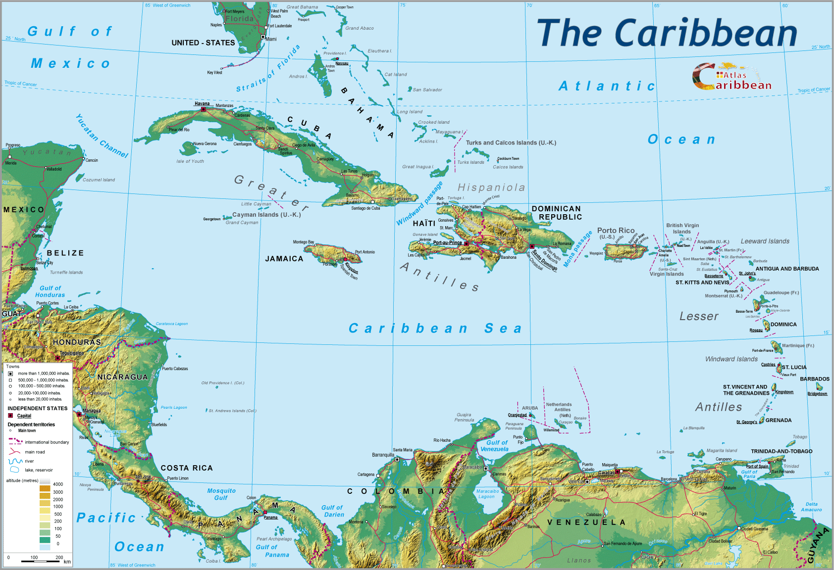
1.1.1. A garland of ever-smaller islands, set in an arc from Florida to the Orinoco Estuary
Some islands are volcanic (the Lesser Antilles), other are coralline in their make-up (Bahamas, Barbados, Tobago) but all are close to one another. There are no isolated islands as in the Pacific and South Atlantic.
1.1.2. The Middle-American isthmus, narrowing progressively from the Rio Grande to the Gulf of Urabá
It is an isthmus whose very mountainous central spine is asymmetrical. The slopes are less pronounced on the Caribbean side, and much steeper facing the Pacific. The calcareous Yucatan peninsula divides the maritime basin with the Antillean arc between the two: the Gulf of Mexico to the North, and the Caribbean Sea to the South.
1.1.3. From the isthmus of Panama to the Orinoco Delta:
A region defined by the northern termination of the Andean mountain chain where it comes into contact with the Guyanese basement rock and its grit stone overlay.
1.2. A 'Mediterranean' fed by the mass of waters warmed by equatorial currents
To the North, the sheaf-like line of coast from the Yucatan to Florida is enriched by large quantities of water borne material brought by the Mississippi and its tributaries. Exiting via the Straits of Florida, these waters mark the departure point of the Gulf Stream.
To the South, the Caribbean Sea is fed by equatorial waters directed through the arc of the Lesser Antilles provoking strong currents between these islands. The general westward shift of waters bends towards the North to the Gulf of Mexico. On its southeastern flank this sea is affected by the very turbid waters originating from the Amazon, and particularly the Orinoco.
These seas are deep (e.g. the trench to the North of Puerto Rico). The continental shelf is rarely found around the islands, except in the Bahamas archipelago and on the southern coast of Cuba. Along the western edge of the basin, only the Yucatan has a large continental shelf mirroring that of its Florida equivalent.
1.3. A greatly and naturally unstable tropical world
1.3.1. High rainfall
Rainfall is abundant without any marked dry season except in North and North-East Mexico. Insularity accentuates the rainfall1. All the same, a gradient is just about evident between a drier North and the equatorial South. Across the islands, the seasonal trade winds define different zones, “windward, and leeward” the sheltered positions found within the deep Andean valleys of Colombia, or in the oppositions between the Caribbean and Pacific coasts of the isthmus.
1.3.2. A triple threat – seismic, volcanic, and cyclonic
- A crossroads position between very active tectonic plates makes the Caribbean a very risk region.2
- An intense degree of volcanic activity. The zone forms part of the Pacific “ring of fire.”
- Recurrent cyclonic activity, of increasing frequency and more and more violent to the North of 5° N, striking both the islands and the mainland coasts.
These natural catastrophes are highly destructive and weaken the regional economic base. Apart from the human loss of life (the Haitian earthquake of January 2010 cause over 250 000 deaths, with 1.5 million left without shelter), the material damage is often considerable, as such to the infrastructure, and both public and private buildings, as from lost resources and destroyed goods. The costs of such catastrophes rise with improved regional standards of living. All the same, the very significant variations in matters of organisation of emergency services produces a very differentiated geography between well-prepared states (French Antilles) and those still deficient (Haiti, Central America).
1.4. A dominantly East-West meteorological system for coastlines not conducive in respect of ports of call for modern ships
The climatology of the Caribbean, and more particularly the Caribbean islands is dependent on the seasonal displacement of air masses from the Atlantic. The Azores anti-cyclonic system determines the regional aerology and generates trade winds whose dominant direction is east-west, with a north-east/south-west inflection at the beginning of the year, followed by a south-west/north-east trajectory, in turn followed by the cyclones on their arrival in the region.
These circulatory movements affect all navigation by sail, and on any transatlantic crossing one must pass around the Azores anti-cyclone, whether by the northern or southern route. The latter option was the east-west route preferred during the colonial period, whilst the return route exploited the Gulf Stream in order to come back to Europe North of the anti-cyclone.
The islands offer coastlines with little vantage to port development. The frequency and orientation of trade winds, and the longitudinal alignment of the Lesser Antilles, Virgin Islands as well as Trinidad, leaves them very largely exposed. 'Windward,' they remain open to the full force of the Atlantic swell against a volcanic morphology, often fractured, and not offering secure mooring sites. ‘Leeward,' the rectilinear trace of the coastline reduces the number of possible harbours. The coralline morphology of some islands (Bahamas) produces greater expanses of flat outcrops, and access channels are rare. Overall, Antillean ports lack either deep water and shelter, or sufficient landing areas adjacent to the quayside.
Along the Central American isthmus, the Caribbean coastline is largely low-lying, humid (mangrove), and unattractive. Port developments allowing anchorages are very few because of lack of depth and the rectilinear character of a coast often punctuated by sand rimmed lagoons.
The Caribbean coastline of mainland South America alternates between capes and bays in Colombia. By contrast the coasts of Venezuela are mainly unbroken (with the exception of the Gulf of Maracaibo). The vast delta of the Orinoco and the Guyanese coasts border a forested zone that gives way to mangrove. The power of the rivers which emerge through the latter is checked by their turbidity, creating highly mobile mud bars in the estuaries, in turn limiting the depth of water and available draught.
1.5. A hampered terrestrial mobility
1.5.1. An aggressive climate and infrastructures costly to build and to maintain
Humid, tropical erosion is ten times more invasive than under temperate conditions. This powerful rate of erosion is often linked to a brutal rainfall regime accentuated by breaks of slope. A a consequence, reinforced terraced banks are frequent on all steep slopes using varied materials, but easily prone to movement under heavy rain. The clayey nature of tropical soils lends itself to landslides. Accordingly, the tropical erosion cycle favours an alternation between hyper-humid, level surface areas and steep slopes easily gullied.
1.5.2. Inland water courses barely usable for navigation
The huge contrasts in rainfall provoke brutal variations in river levels (llanos in Venezuela during the rainy season). The course profiles of tropical rivers are very irregular, alternating between slow moving reaches and numerous, sudden breaks of slope (cascades, falls) upstream. Aggressive erosion results in heavily laden waters upstream (torrents across rocky beds) and highly turbid waters downstream. The result is a variance in contact between waters emanating from the river and those from the incoming sea: the heavy loads of sediment carried by the Orinoco and the rivers of Guyana, Colombia, and the isthmus territories are swept out to sea and counteract the formation of real estuaries. More often, the result is the formation of deltas with multiple shifting outlets that constrain the possibilities for navigation.
All the same, regularly maintained, costly engineering works allow merchant ships to access the lower reaches of the Orinoco, and the downstream sections of the Guyanese and Colombian rivers.
1.5.3. The nature of Caribbean topography thwarts transport networks by multiplying the resulting infrastructural “works of art”
The confined topography of the volcanic islands favours coastal 'ring roads' so as to avoid the mountainous central terrain.
In Central America, historically the siting of capital cities in the mountainous interior meant that communications with the newly expanding Caribbean coastal areas, as a result of export led agricultural production, became particularly expansive. The same applies to the necessary transport infrastructure linking Bogotá or Caracas to their Caribbean port outlets.3
In the Guyanas, all land-based communications have been realised only with extreme difficulty in terms of pushing route-ways through the evergreen rainforest, and bridging numerous fast-flowing rivers perpendicular to the coast.
2. The weak pre-colonial human imprint in a time and space without wheel or pack-animal
Comments on this legacy will be limited to the period immediately preceding European colonization.
The peoples of the middle-American isthmus lived within very hierarchical societies, frequently at war and dominated by ethnic groups originating from the North. Accordingly, one can record the ultimate Aztec domination dating back to Tenochtitlan, and which stretched southwards as far as the lands of the Maya, centred on the Yucatan forest.
The source of political power came from the mountains, where the religious sanctuaries were to be found, centres of veneration and densely settled. It demanded numerous tributes from subject peoples, both from the mountains and the coast. The exercise of this power required moving around the region but uniquely on foot, largely carried out by official couriers along well-established and constructed routes, regardless of topography, in order to link up the main religious centres. Packaged goods were again transformed solely by human effort.
In the Andean mountains of “Terra Firma” (the future Colombia and Venezuela), pack-animals were used on the high plateaux. The coasts of the isthmus, particularly on the Caribbean side the locus of coastal trade by means of dugout canoes, using the numerous lagoons and rivers of the Gulf of Mexico as far as the Panama isthmus.
The forested world of the Guyanese shield and its margins was only very partly inhabited by hunter-fishermen using the numerous watercourses throughout the area. Their knowledge of navigation allowed these peoples of the Orinoco basin over several centuries to embark on the conquest by canoe of the islands of the Lesser Antilles arc, from their estuarine base.4
In this Amerindian world, the Lesser Antilles formed an ensemble where maritime transport was in frequent use, and served to integrate each island within a larger whole, thinly populated, non-hierarchical, combining fishing, food gathering, cultivation of cassava, with exchanges between islands. This mobility was above all longitudinal in direction, following either the Caribbean coast, or doubtless less frequently, the rougher Atlantic coast. The intensity of this coastal movement was very much influenced by weather conditions, and had to cope with the difficulties of navigating the sea currents between islands given their dependence on only oar-powered craft.
Thus out of this pre-colonial period we retain a double Caribbean mobility constrained by their very limited control of nature, and the quasi-total dependence on just human labour. Across the Lesser Antilles, the Caribbean Sea would play the role of a true social matrix of communication, thanks to their mastership by means of the 'Kalinas' canoes of this fluid watery space. In the Greater Antilles, the archaeological evidence has not been found to show what doubtless would have been a degree of a coastal exchange between the innumerable islands of the Bahamas archipelago and that around the coasts of Cuba.
On the other hand, were there maritime links, other than of an exceptional or occasional nature, between the Antillean arc and the Central American isthmus around the Yucatan and the eastern extremity of Cuba? This longitudinal axis in mobilities, and therefore in power relations, and the associated stakes, would not be seen again until after the transatlantic hegemony of European colonization.
So the pre-colonial Caribbean appears to be a closed world in relation to both the West and the East, but it was not immobile. Men walked the paths forged across the mountains of this 'Terra Firma,'5 and paddled along the coastlines of the isthmus and the islands, as well as along the innumerable watercourses through the vast mainland forests. Trade, whether through coercion or barter used the same routes.
1 Despite its tropical location, Guadeloupe has a rainfall pattern that is quasi-equatorial, equivalent to that of Gabon.
2 The recent earthquakes in Haiti (January 2010) exceeded 7 on the Richter scale. A year later, only 5% of the building debris (30 million m3) had been cleared and no real reconstruction begun.
3 The city of Caracas is situated only a few dozen kilometres from the coast, but separated by a mountain chain exceeding 2 500 metres in height.
4 The 'Kalinas' use two types of boat: “couliala,” a dugout canoe some 6-8 m. long, for family and daily navigation over short and medium distances, and the “kanaoa,” a canoe up to 20 metres long for major expeditions, able to carry up to 50 men (see J.P. Sainton (ed.), Histoire et civilisation de la Caraïbe, tome 1, p. 76-77). During one of his visits in Dominica during the 1970s, the author of this article himself saw this type of canoe construction, chiselled out of the trunk of a “gomrnier” tree using fire-heated stones.
5 Archaeological ruins of Aztec and Maya cities have revealed sections of stone paving used to provide routes between certain cultural centres.
top
|
  |
© 2007-2025 University of Caen Normandy,
CERTIC, UMR CNRS 6590 ESO, AREC, Research and Studies Association on Caribbean area, All Rights Reserved.  |

