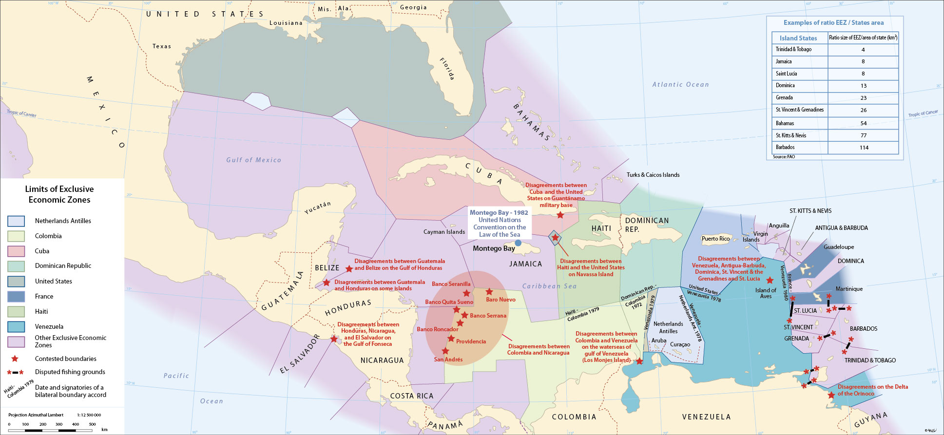
Covering some 4 300 000 km², the Caribbean Sea and the Gulf of Mexico dominate their surrounding but frail continental or island perimeter arc. From the pre-Columbian era to modern times and through to the present, it is the multiplication and juxtaposition of zonal entities that have prevailed. Notwithstanding their vast surface dimensions, this maritime space is today entirely divided between bordering states. These invisible yet real boundaries which cut up this liquid expanse afford the region an image as complex as, but very different from, the classic political map. The smallest island can suddenly take on an unsuspected dimension, the ambitions of certain regional powers reveal themselves, and the stakes in play change in both nature and scale.
The fragmentation of the region, the short distances separating islands, the economic, political and ecological issues (for example, the position taken by the Association of Caribbean States against the passage of ships transporting nuclear waste), the unequal means at the disposal of states to exploit and keep watch over their maritime domains… all combine to turn the sea into a sensitive space, a potential locus of litigation where problems of neighbourly relations and sovereignty are transferred and focused. The frequent boarding of foreign boats caught fishing in other countries' national waters highlight persistent bones of contention between some islands (such as between French departments and their Anglophone neighbours): some even end up at the International Court of the Hague. During the colonial era, for the great powers the sea was hardly more than a means of communication, where freedom of passage (Mare liberum) and security simply needed to be guaranteed, but with the birth of numerous independent states and also the development and exploitation of its resources (whether halieutic or mined), the sea has now become a much coveted space.
In the 1970s, an international code, the 'law of the sea,' was put in place, which accorded to coastal states almost total sovereignty across a zone 12 miles wide, designated as territorial waters, and rights of exploitation over a zone of 200 miles (EEZ or Exclusive Economic Zone). Ratified in 1982, the convention of Montego Bay (Jamaica) recognizes and agrees this code… but not all states signed up, including the United States. The application of this code leads at times to surprising outcomes. For example, Venezuela's claim that the Aves Island, a coral-covered sandbank some 560 km north of its mainland sustains human habitation (a small military outpost), a criterion under UNCLOS, has resulted in the state being accorded a vast, albeit still hotly contested, EEZ. Columbia similarly benefited thanks to its island of Saint Andres. This has served to consolidate further both states ambitions as regional powers. The fishermen of the French Antilles (DFA), on the other hand saw themselves excluded from traditional fishing grounds which they had historically frequented.
Despite the enactment of the code, many problems of delimitation are on hold, while multiple special exemptions remain in force: bilateral accords, concessionary fishing rights to foreign fleets, tacit agreements for the fishing of great migratory pelagic shoals. The maritime space of the Caribbean remains a potential source of tension and conflict. CARICOM's attempt to maintain a unified front is clearly threatened.
top
|
  |


