


- Caribbean mobilities
- Colonization: an indelibly engraved imprint
- Dialogue on caribbean migration
- Freedom and new mobilities (19th C)
- Les décisions récentes de la politique migratoire en République Dominicaine FR
- Les migrations intra-caribéennes (2020) FR
- L’immigration haïtienne en République Dominicaine FR
- L’ "anti-haïtianisme" en République Dominicaine ? FR
- Migraciones de Haicianos ES FR
- Migrations (1960-1990)
- Migrations (1990-2010)
- Migrations 2010-2017 FR
- Migrations : nouvelles tensions FR ES
- Migrations intra-caribéennes FR
- Mobilities of violent appropriation
- Mobilités pendulaires et macrocéphalies urbaine et professionnelle : le cas de la Guadeloupe et de la Martinique FR ES
- Revolutions in energy and transport
The arrival of the Europeans in the Caribbean constituted a primordial event for the region, and indeed for the history of the world. Schematically, it can be divided between two major colonial systems: the earliest and most extensive was the Spanish colonial regime, which was rapidly established following the voyages of Christopher Columbus, from the start of the 16th century. It covered the whole of the Caribbean basin, effectively occupying the Greater Antilles (Cuba, Hispaniola, Puerto Rico, Jamaica) which formed the first bulwarks of an empire that would include the isthmus of Mesoamerica and Andean South America.
The second system would impose itself across the Lesser Antilles, in Jamaica, western Hispaniola and the Guyanas from the 17th century onwards under the iron rod of the other European powers: France, Britain and the newer Low Countries. This slave-based mercantilism founded on cane sugar plantations would transform these “sugar islands” into a transatlantic colonial periphery, which became particularly lucrative for Europe, wracked in the 18th century by Anglo-French conflict.
The Spanish colonial project was largely about mining
A system more predator than producer
The goal of the Spanish conquistadors was to avail themselves of the riches of the newly conquered territories. These riches would stem from pillaging the defeated Amerindian populations, then the precious metals of the local open cast mines using local forced labour, later to be imported.
The distribution of both populations and land between the conquerors imposed a system of quasi-slavery, or at least a terrible servitude on the Amerindians compelled into forced labour. The contact between the two worlds proved brutal and bloody, translating itself into what many authors have labelled as the genocide of the Amerindians, as much on the continental mainland as in the Greater Antilles. Several million human beings disappeared in just a few decades, through war, maltreatment, and new diseases transmitted by the recent arrivals.
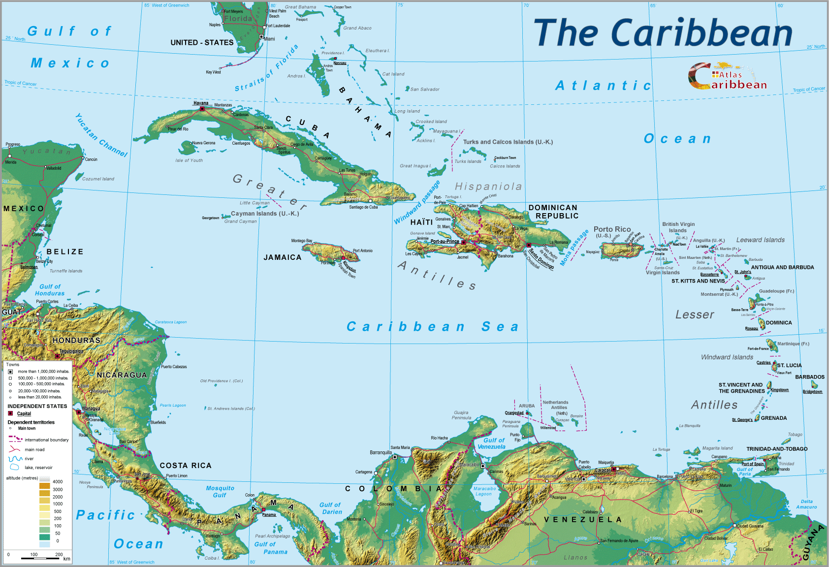
The whole notion of mobility was upended. The Atlantic now commanded by European navies, meant a considerable expansion of the territory occupied by the ‘Old World’, which on its own terms has just annexed a ‘New World’, called America. The Caribbean basin was at its heart, enclosed to the West by a long peduncle of isthmic territories, and open to the East by an arc of islands diminishing in size from North to South.
Few in number but determined and unscrupulous, the Spanish made sure their rapid domination over almost all the local populations thanks to an array of logistical equipment unknown to the latter.
The first of these was clearly the caravel itself, a ship that allowed the crossing of the Atlantic. This high sea ship of a weight of a few hundred tons, combined the qualities of the square-rigged Baltic cog with that of the triangular rigging of the Mediterranean ships. To better marine charts, better navigation instruments1 was added the tried and practised use of the trade winds for the Atlantic crossing.
Logistically, this ship would become the major element in the European colonization of America. Ultimately, it would help re-orientate the polarity of Mesoamerica, hitherto aligned longitudinally, to a strategic east-west axis linking the European metropole to its colonies.
The system put in place by Spain was centralised, monopolistic and rigid, in the image of the Spanish monarchy that had become imperial with Charles V. All communication between Spain and its new colonies was centralised in Seville by the ‘Casa de Contratación,’ and was carried out solely under the Spanish flag. This maritime monopoly of the national flag would be copied later by the other European colonial powers. It gave the navy a vitally important role in the enduring history of transatlantic links and, above all, in the gains that the metropole extracted from this mercantilism, dependent on a maritime logistical chain which was long, costly, and hazardous.
This in turn demanded the possession of a substantial ocean-going fleet capable of transporting the fruits of colonization, of satisfying the needs of the overseas colonial population, as well as defending the whole enterprise against enemy action. In order to protect the precious galleons transporting precious metals extracted from the mines, it also required fortified garrison ports, vital logistical nodes in the long chain that led from the mine to the imperial treasury. These precious metals in due course stamped by the colonial administration effectively gave economic power to those holders in a western world in which the currency as above all metallic.
The Spanish hoped to protect their galleons by organising them into convoys, escorted by warships.2 The geography of this transhipment is well known. The different ships loaded with their colonial treasures would be brought together in Havana. They had arrived from Santo Domingo (in the case of Hispaniola), from Cartagena (“Terra Firma”), from Portobelo, after the land crossing of the Isthmus of Panama (from the Peruvian mines). Acapulco, on the Pacific coast was the gathering point for galleons from the Philippines whose cargoes were transited via Mexico before being embarked at Veracruz. From Havana, the convoy headed for the redoubtable Florida Strait before engaging the Atlantic crossing, helped by the Gulf Stream.
The Spanish conquerors introduced both the horse and the mule, two pack animals that would revolutionise land transport in a region, which until then, had not seen the wheel and carthorses. From then on the horse became as much the faithful charger of the warrior as the mount of the white master. This animal would contribute to the birth of a veritable civilisation founded on its strength, its freedom of movement. It allowed putting of the rearing of cattle and sheep, other imported animals, providing the basis of the colonist’s meat diet. To the Spanish primary goal of mined wealth was added the distribution of land, farmed in very extensive fashion and used mainly for pasture. Towns were created adopting a colonial social system that reproduced the feudal hierarchy of the Iberian metropole, founded on a division of farmland which excluded the local population, forced to provide labour, suppressing with total disregard their local customs and languages.
The mule was an excellent draught animal, particularly as a beast of burden, adaptable to all terrains and weather conditions. It became the ideal instrument of European conquest, largely responsible for the carriage of heavy loads of precious metals, but also spices across the Isthmus of Panama or of Acapulco to Veracruz via Mexico. Harnessed, it could pull drays and carts. But colonial roads were few and the “Camino Real” from Mexico towards the isthmus was often far from usable.
The conquered indigenous society passed from its very hierarchical, pre-colonial structure to a quasi-incarcerated colonial order that confined them within their own social sphere or consigned them to working in the mines. Their rare opportunities to move around were limited, always on foot and dependent on the goodwill of their master.
The occupation of the colonized space remained incomplete, indeed hazardous given the number of Spanish settlers available to control and develop such vast territories. Towns were founded, the main ones re-using the original sites of the principal pre-colonial centres (Mexico and Tenochtitlan). But the colonial system depended on ports along the Caribbean mainland coast (Veracruz, Portobelo, Cartagena, Maracaibo), and also along the Pacific coast (Acapulco, Panama). Most of the mining activity was located on the high plateaux of New Spain (Zacatecas). The Spanish occupation was much more slack across the southern part of the isthmus. The two ports of Panama and Portobelo, of vital importance to the “flota” system, were situated in the heart of extensive areas of forest. Similarly, New Grenada appeared as an archipelago of key strongholds, held by the new colonial masters and often in coastal locations (Cartagena, Maracaibo, Santa Marta), with the exceptions of Bogota and several important rural centres in the Andean valleys. The vast forests of the Guyanese shield, like the llanos of the future Venezuela were known to but a few explorers.
Extensive cultivation proved to be the central characteristic of the opining up of the farmlands of the Spanish Empire. The end of the 17th century, and especially the 18th century, would see the development of plantation agriculture (sugar cane, tobacco, cocoa) across the mainland coastal plains, with its enslaved black labour force (the region of Veracruz, the isthmus of Tehuantepec, the Caribbean coast of New Grenada). The produce from these plantations served the needs of the colonial settlers, but more importantly were added to the cargoes of precious metals, spices, and leather destined for Spain. In return came products indispensable to the lives of the livelihood of the settlers (timber, cloth, flour, tools, arms) and to keep up their position in a hierarchical feudal society (luxury woven fabrics, furniture, wines and alcohol, silverware, crockery).
In this empire, more or less under control, the autochthonous peoples in their forests continued to use their old waterways, in the same way as the isolated Andean mountain peoples walked their century-old tracks, whilst river, coastal or intra-montane circulation from now on was under the military control of the Spanish rulers.
The strategic importance of the Greater Antilles in Spanish colonial logistical planning
The colonization by the Spanish of the Greater Antilles proved brutal and predatory. The replacement of the “repartimiento” system by that of the “encomienda” would see lands and people shared out between the new masters as simple instruments of labour, effectively slaves in all but name. This enslavement of the Amerindians was officially abolished in the middle of the 16th century; the colonists replacing the latter with Africans supplied by the slave trade. Within a few decades, the population of the Greater Antilles had been decimated. The farming of the land was destined to be given over to extensive stock rearing within the vast “estancias.” The areas inland were little inhabited (Puerto Rico, Jamaica). The cultivation of sugar cane and tobacco was established in Cuba and Hispaniola, but over much reduced areas. The western part of Hispaniola was fairly quickly abandoned, whilst the English were able to take hold of sparsely settled Jamaica fairly easily in the middle of the 17th century.
The Spanish were never fully able to dominate and to settle across the whole of the Lesser Antillean arc. Without doubt the latter offered less accessible riches (gold and silver), but also the Kalinas defended themselves much more effectively than the Amerindians of the large islands. The contacts between Spanish and Kalinas were not war-like: the former used the islands for fresh water and food supplies; which added up to only occasional landings during the 16th century.
As regards the future Spanish Empire in America, the Greater Antilles would provide the bases for the eventual conquest of the continental mainland. Once accomplished, these islands would become the maritime keys of the new Empire. They effectively controlled the main points of entry and exit for commerce and trade. Cuba closes the southern entrance to the Florida Strait, and shares control of the Windward Passage with Hispaniola. More to the East, the latter controls the Mona Strait with Puerto Rico. The South American coastal could be kept under observation from Trinidad. As such, Spain controlled the larger part of Caribbean maritime space by its holds on the isthmus and the continental mainland. The port capitals of Cuba, Hispaniola, and Puerto Rico also acted as the advance barbicans of the Spanish colonial fortress. Today, the scale of their fortifications clearly reveals their particular architectural influence within Caribbean urbanism.
1 Colombian maritime science capitalised on advances made by Portuguese navigators during their long peri-African journeys, as well as those resulting from the navigations of sailors from northern Europe in the North Atlantic.
2 This system of escorted convoys, put in place in 1543, was re-utilised during the two world wars by the Anglo-American fleets, to protect themselves from German submarines
top
|
  |
© 2007-2025 University of Caen Normandy,
CERTIC, UMR CNRS 6590 ESO, AREC, Research and Studies Association on Caribbean area, All Rights Reserved.  |

